


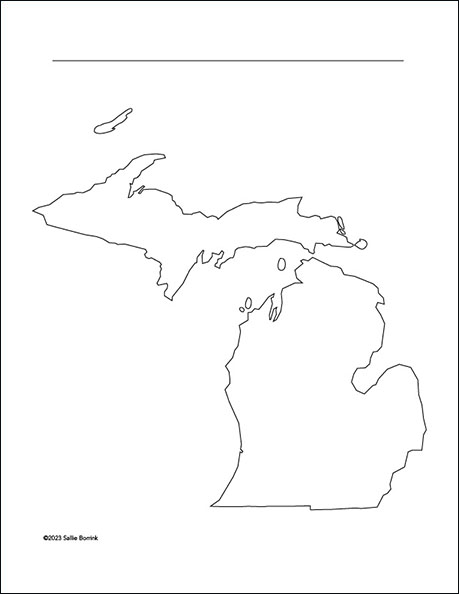
This free blank Michigan map printable is a simple resource you can use again and again in your homeschool. It works well for geography lessons, state studies, notebooking, research projects, and hands-on learning for a wide range of ages.
Over the years, blank maps have been one of those quiet, dependable tools in our homeschool. Children can label places, mark historical events, trace natural features, or add notes from their reading. Because the map is unlabeled, you can adapt it to whatever you are studying right now.
Michigan is an especially interesting state to explore on a map. Its two peninsulas, Great Lakes shoreline, major cities, and rich history all give children plenty to notice and remember.
Download Free Printable Map of Michigan
By downloading this free printable, you are agreeing to my Digital Products Terms of Use. Thank you for respecting my work.
Click here to download the free Michigan map printable PDF
Ways to Use This Michigan Map in Your Homeschool
- Label the Upper Peninsula and Lower Peninsula.
- Mark the Great Lakes that border Michigan.
- Add major cities such as Lansing, Detroit, Grand Rapids, and Traverse City.
- Trace important waterways, including rivers and straits.
- Use it for a Michigan state report or notebooking page.
- Color regions connected to agriculture, manufacturing, tourism, or forests.
- Mark important places in Michigan history.
- Create a family travel map of places you have visited or hope to visit.
Ideas for a Michigan State Study
If you are building a simple state study, this blank Michigan map gives your child a place to gather what he or she is learning. Younger children might label the capital, a few cities, and the surrounding lakes. Older students can add historical notes, economic regions, natural resources, or major transportation routes.
This map also works well across subjects. Use it with history to mark settlement patterns or important events. Use it with science to note the Great Lakes, climate patterns, or natural regions. Use it with literature or family reading to track places mentioned in books connected to Michigan.
Because the map is open-ended, it can be used more than once. Print one copy for basic geography, another for history, and another for a final notebook page or report.
Printing Tips
This Michigan map printable is provided as a PDF for easy home printing. You can print it on standard paper for everyday use or on a heavier paper if your child will be coloring, labeling, or adding notes. It also works well in folders, binders, and state study notebooks.
Michigan Map Printable FAQ
Is this Michigan map printable free?
Yes. This blank Michigan map is free to download for your personal and homeschool use under my terms of use.
Is this a labeled map of Michigan?
No. This is a blank outline map of Michigan so you can customize it for your own lessons and projects.
Can I use this in my homeschool?
Yes. You may print and use it in your own homeschool with your children.
What is included?
This free download includes a printable PDF map of Michigan.
Complete Your Geography Collection
 If this free Michigan map is helpful, you might also enjoy my 50 Blank U.S. State Maps Bundle.
It includes every state outline plus Washington, D.C. in one organized file for easy printing whenever you need it. This is a practical resource for homeschool families who want a full set of clean, versatile maps ready for state studies, notebooking, reports, and geography projects.
Features: Instant download • All 50 states plus D.C. • Multi-grade adaptability • Cross-curricular applications
Leave a Reply